

Attraction Details
Overview
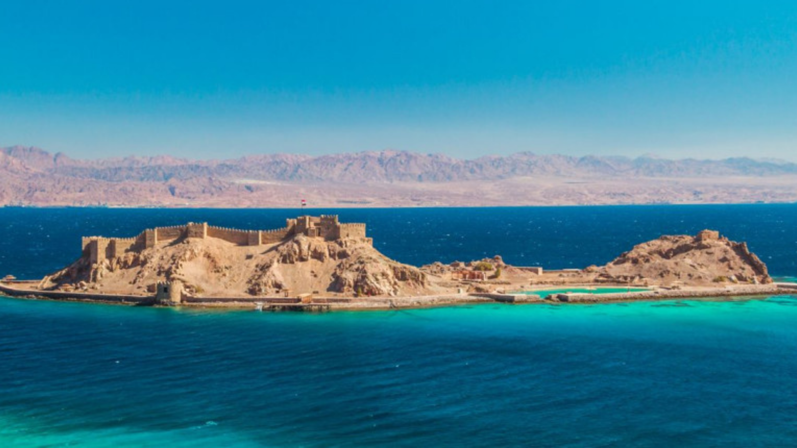
Pharaoh’s Island (Geziret Faraoun — also known as Coral Island)
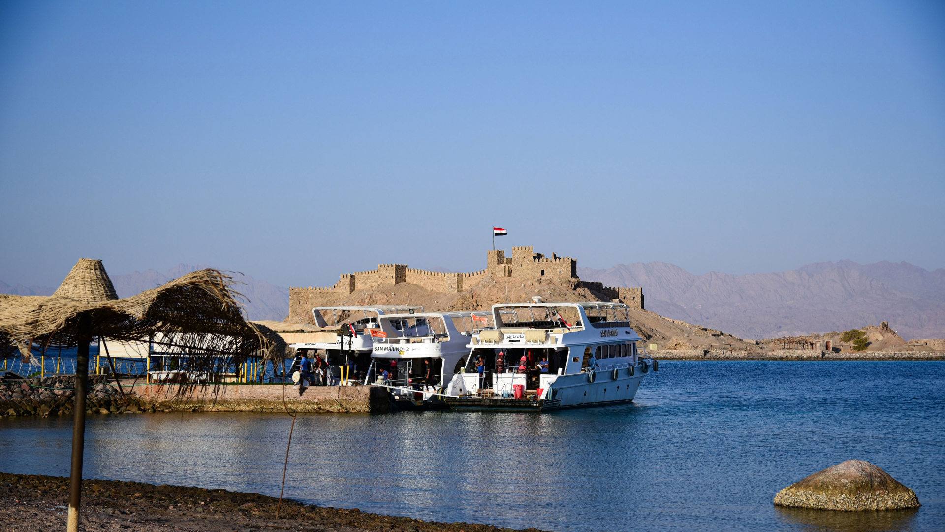
It’s is a small Crusader-era fortress island in the Gulf of Aqaba, approximately 7 km south of Taba at Egypt’s northeastern Red Sea tip. The island is dominated by a well-preserved medieval fortress built by the Crusaders in the 12th century and subsequently captured and expanded by Saladin’s forces in 1170 CE — an extraordinary historical artifact at the precise intersection of the ancient Egyptian, Crusader, and Islamic worlds. The fortress walls, towers, and interior chambers survive in good condition and the island’s elevated position gives panoramic views across the Gulf to Jordan, Saudi Arabia, and Israel simultaneously.
The island is reached by a short motorboat transfer from the mainland jetty south of Taba, and the journey itself is part of the experience — the approach to the island, with the fortress walls rising from the water and the surrounding mountains of four countries visible on the horizon, is one of the most visually dramatic short boat rides in Egypt. Snorkeling around the island’s coral-fringed base reveals healthy reef systems with abundant fish, though the main draw is the fortress itself.
Pharaoh’s Island is associated in tradition with King Solomon and his trading ships, though the current fortress structure dates entirely to the Crusader and Islamic medieval periods. Its position at the strategic crossing point of ancient trade routes between the Mediterranean and the Red Sea gives it historical significance well beyond its modest size.
History & Significance
The island was fortified by the Crusader King Baldwin I of Jerusalem in 1116 CE as part of the Crusader attempt to control the Red Sea trade routes and the pilgrimage road to Mecca. The fortress — known to the Crusaders as Ile de Graye — was a strategic outpost monitoring shipping in the Gulf of Aqaba and taxing the merchants and pilgrims who passed. It was captured by Saladin in 1170 CE following a siege, becoming one of his first military achievements in the campaign against the Crusader states.
After the Islamic conquest, Saladin expanded and strengthened the fortress, and it continued to be used through the Mamluk period. The fortress eventually fell into disuse and was abandoned, preserved by its island position from the stone-robbing that destroyed most medieval structures on the mainland. Its survival is therefore accidental — the difficulty of transporting stone from a small island made it economically unattractive to demolish.
What to See
Crusader-Islamic Fortress
Well-preserved medieval fortress walls, towers, and interior chambers built by Crusaders and expanded by Saladin — one of the most complete surviving Crusader military structures in Egypt.
Four-Country Panorama
From the fortress ramparts, the coastlines of Egypt, Israel, Jordan, and Saudi Arabia are simultaneously visible — the only point in the world where four nations' shores are seen at once.
Boat Approach
The 10-minute motorboat crossing from the mainland, approaching the island with its fortress walls rising from the Gulf water — one of Egypt's most dramatic short boat journeys.
Coral Reef Snorkeling
The coral-fringed base of the island offers excellent snorkeling directly from the landing area — healthy reef and abundant fish accessible without a separate boat trip.
Photo Gallery


Visitor Information
Daily 8:00 AM – 5:00 PM
⛔ Closed: NeverNo dress restrictions
Photography is free
Limited accessibility
💡 Visitor Tips
Location & Map
🚕 How to Get There
Located 7 km south of Taba; take a taxi to the mainland jetty (15 min from Taba center), then motorboat transfer to the island (10 min). Boats depart when sufficient passengers are assembled.